Little Pawnee 12,466'
Little Pawnee from Blue Lake (north). Photo: Rob Writz
There is really nothing little about Little Pawnee. On a map it looks like the East Ridge of Pawnee, but its stature in the Blue Lake and Pawnee Pass areas is impressive. In the Blue Lake area, most Front Range ski mountaineers are on their way to Mount Toll or Mount Audubon and usually ignore the couloir festival going on the north side of Little Pawnee Peak. These couloirs are calling to be skied, and if the spring conditions are right one or two of these could be an early afternoon ski post-Toll. In the descriptions below we stick to the practice of climbing these couloirs before skiing them, but some Front Range ski mountaineers mix it up by climbing the Class 3 East Ridge of Little Pawnee to reach the tops of the couloirs. The ridge does not involve a Class 3 maneuver until above the North Couloir East’s notch.
+ ROUTES
Shared Approach to Tarn at 11,040'
The couloirs on the North Face of Little Pawnee share a common approach to the small tarn southeast of Blue Lake. This is accessed from the Mitchell Lake Trailhead on the Brainard Lake Road. Ski or hike approximately 1.8 miles from the Mitchell Lake Trailhead to this tarn. The Mitchell Lake and Blue Lake summer trail will lead you to take you right to this tarn, but the trail can be hard to follow when it is covered in snow. An alternative is to skirt to southwest side of Mitchell Lake and proceed west and southwest through low angle and open terrain to regain the approximate line of the trail. Whether you are on the trail or skiing cross country your goal is the small tarn southwest of Mitchell Lake at 11,040’.
Route 1 - Little Pawnee Headwall
- Rating: II D6 - D8
- Season: Spring, Summer
- Exposure: Northeast
- Vertical: 1,150'
- Approach Elevations: 10,080' - 12,200'
- Approach Distance: From Mitchell Lake TH: 2.2 miles, from Brainard Lake Gateway TH: 5.2 miles
Little Pawnee Headwall, along with the Autobon Couloirs across the valley on Mount Audubon, provide highly accessible steep skiing that does not involve the full commitment of climbing a large mountain. These routes are accessed quickly from the Mitchell Lake Trailhead, and some skiers often climb the blunted ridge to the east to gain entrance to the chutes. The better practice is to climb what you ski. The eastern headwall (1a, D6) is not as steep as the chutes on the west side, but it does have melted out talus and small cliffs that can create a complicated central line. The central couloir (1b, D6) is a clean line of similar pitch but with a distinct hourglass entrance into the lower couloir. The western couloir (1c, D8) is a beautiful chute with a tight ski entrance that may deteriorate by June. All three of these lines are skiable into June. From the tarn at 11,040’ look up and then climb up.
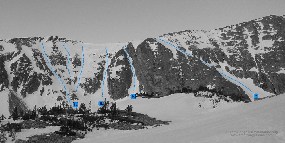
Little Pawnee Headwall from the north. Photo: Rob Writz
Route 2 - Obliquity Couloir
- Rating: II D6 R3
- Season: Spring
- Exposure: North, Northeast
- Vertical: 800'
- Approach Elevations: 10,080 - 12,000'
- Approach Distance: From Mitchell Lake TH: 2.65 miles, from Brainard Lake Gateway TH: 5.65 miles
This interesting couloir slants across Little Pawnee’s North Face. It begins west of the North Couloir East and shares an end on the ridge near the Little Pawnee Headwall Couloirs. The Obliquity Couloir is mostly a shallow depression, but there are points with a double fall line that drops the skier in two directions, left and down. A mistake in the upper Obliquity could result in a tumble into the slabs and then a fall down the cliff. The snow can be shallow in the middle pinch of this chute. After navigating the slant, skiers can open up some turns on the lower apron. Continue west pass the tarn at 11, 040’, curve north around the large buttress and the Obliquity Couloir is around the corner.
Route 3 - North Couloir East and Zig Zag
- Rating: II D7, D10
- Season: Spring
- Exposure: North
- Vertical: 800'
- Approach Elevations: 10,080' - 12,300'
- Approach Distance: From Mitchell Lake TH: 2.75 miles, from Brainard Lake Gateway TH: 5.75 miles
This good looking couloir is east of Little Pawnee’s summit block. Being in this couloir is distinctly alpine as you are surrounded by rock walls. It is also dark in here and the sun’s light barely reaches this inset and north facing chute. About half way up the main couloir (3a, D7) a right branch takes you into the Zig Zag Couloir (3b, D10). The Zig Zag Couloir ends on Little Pawnee’s ridge just above the main chute. A Class 3 scramble from the notch or Zig Zag takes you to the summit. As with most of the Little Pawnee Couloirs, there care often rocks present in the couloir. The rocks that fan out at the base of this couloir are usually not covered with snow. From the 11,040’ tarn, continue on the line of the Blue Lake Trail a half mile to Blue Lake. From Blue Lake go directly south to the couloir.

Obliquity Couloir and Zig Zag from the north. Photo: Rob Writz
Route 4 - North Couloir West
- Rating: II D7
- Season: Spring
- Exposure: North
- Vertical: 800
- Approach Elevations: 10,080' - 12,300'
- Approach Distance: From Mitchell Lake TH: 2.75 miles, from Brainard Lake Gateway TH: 5.75 miles
This couloir is a mirror image of the North Couloir East. It resides on the west side of Little Pawnee’s summit. It is a straight forward chute, but does not have an added addition of the Zig Zag. If you are interested in getting to the summit from here, it is a stiff Class 3 scramble in ski boots to the east. The potential to add a rock climb to the summit really sets Little Pawnee apart from its neighbors. Follow the North Couloir East’s approach to Blue Lake and then head southwest to the large couloir west of the summit.
+ TRAILHEAD
Brainard Lake Gateway Trailhead (10,080’) and Mitchell Lake Trailhead (10,480’)
Brainard Lake Gateway Trailhead is the access point to the Mitchell Lake and Long Lake Trailheads. The road from the Gateway Trailhead to Mitchell Lake and Long Lake may not be open to cars until mid-June. Because of this closure the spring and early summer ski adventures in the Brainard Lake area are launched from here. The spacious trailhead at the Gateway is host to a large gathering of backcountry skiers and mountaineers in the pre-dawn hours on spring weekends. When the road opens in mid-June there is an access fee into the Brainard Lake Recreation Area. Access the Brainard Lake Gateway Trailhead on Brainard Lake Drive west of the town of Ward on Highway 72. Drive the road to the end.
Gear up and ski, hike or ride your bike to the Mitchell Lake Trailhead. It is about 3 miles from the Gateway on the Brainard Lake Road to the right turn leading to the Mitchell Lake Trailhead and the Long Lake Trailhead. Go about 0.4 miles straight up this road to the Mitchell Lake Trailhead (the left turn is to Long Lake Trailhead). You can check the status of the Brainard Lake Road at the USFS Roosevelt National Forest Boulder Ranger District Road Status website.
+ MAPS & PICTURES
Below we have included a link to Front Range Skimo's master map. The routes on the map are approximations, and are not intended for use as a GPX track. To the right are a curated list of photos of the mountain.

Clicking on map above will open interactive Caltopo map website.


