Berthoud Pass West: No Name, Pumphouse Basin, Mount Russell, West Side, 80s & 90s
Berthoud Pass West Side from the East. No Name and Mount Russell are visible in the upper left side of the photo. Photo: Rob Writz
Berthoud Pass arguably has the best backcountry skiing and snowboarding east of the Continental Divide and near Interstate 70. US Highway 40 provides numerous basins and access points that allow backcountry riders to spread out. Berthoud Pass West, as described in this guide, includes No Name, Pumphouse Basin, Mount Russell, West Side, and the 80s & 90s. The western portion of the old Berthoud Pass Ski Area included Pumphouse Basin, West Side, 80s, and 90s. The slopes on the West Side ranges from mellow remnants of the old ski area's runs to terrain features and aspects that are conducive to avalanches. You will want to consider skiing the higher terrain on the West Side after the spring snow consolidates. The accessibility of this terrain often lures backcountry riders into dangerous snow conditions. Be careful here!
Interested in taking this information with you to the Pass? Check out our guidebook now available on Rakkup and Beacon Guidebooks.
+ NO NAME AND MOUNT RUSSELL ROUTES
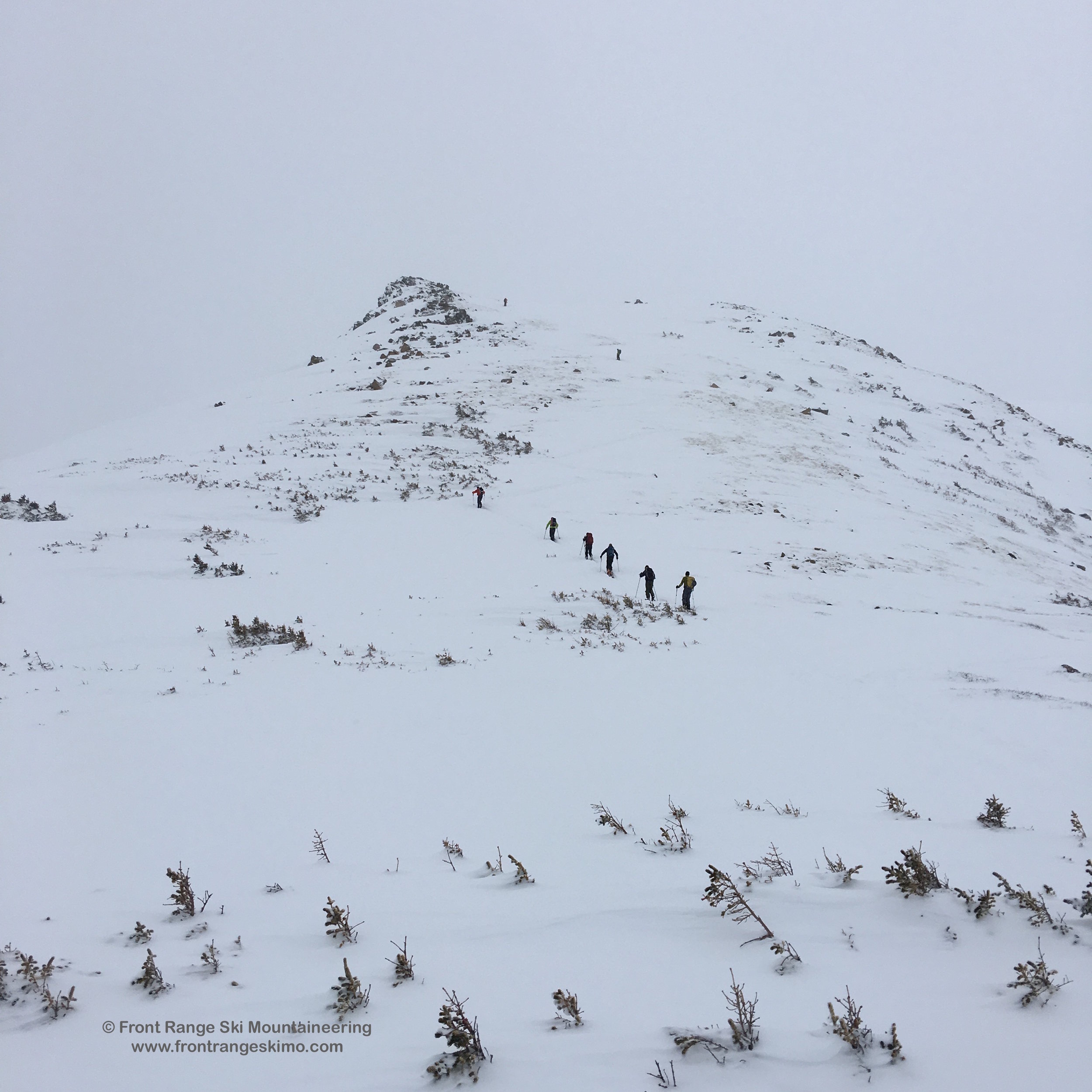
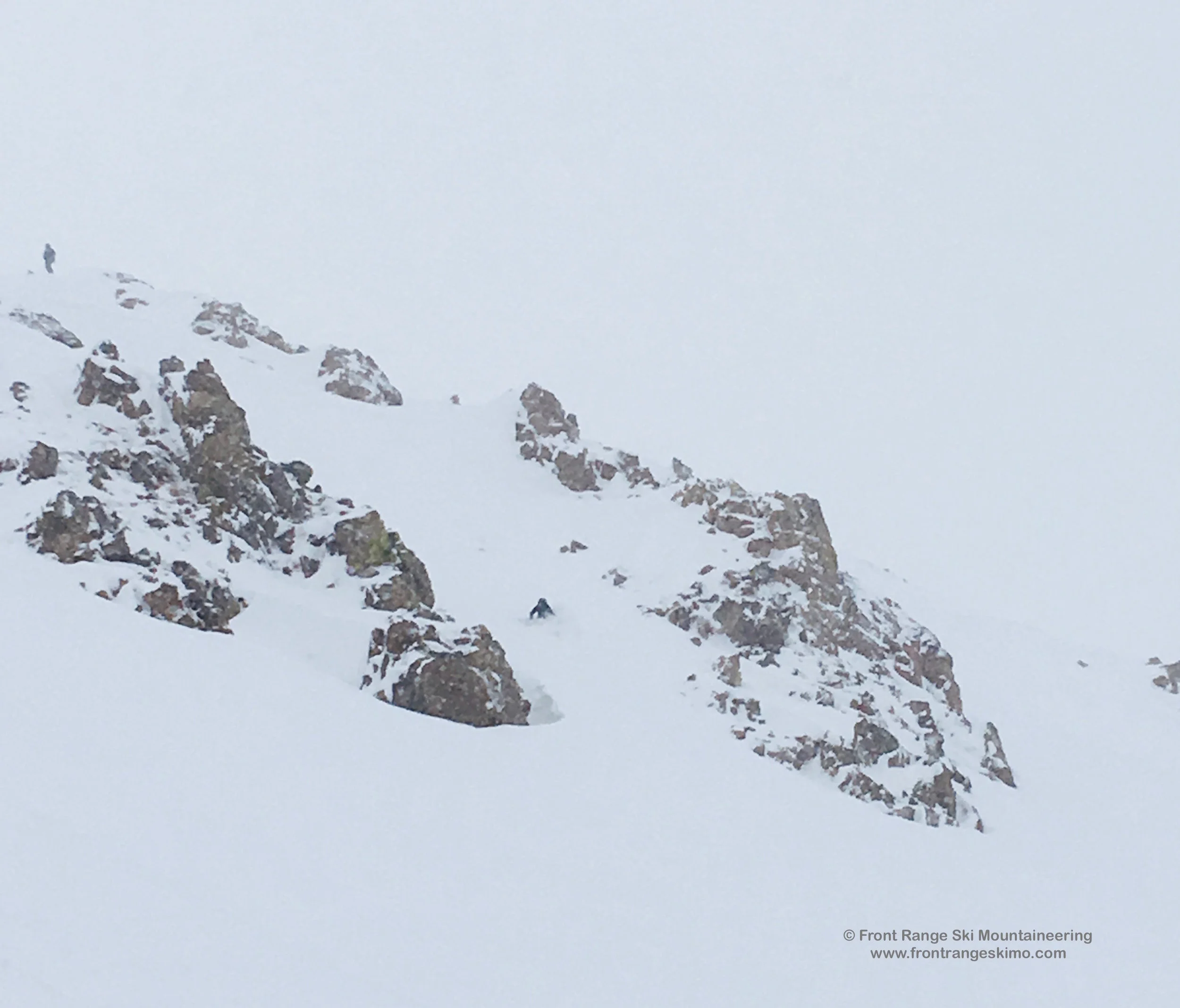
The terrain in the No Name and Mount Russell zones are a beacon calling all Berthoud Pass backcountry skiers and riders to climb higher. These two peaks hold several of the Pass’s most obvious steep lines. No Name’s namesake route is a direct plumb line shot down the snowy face, and Mount Russell has the North Chutes. All of the slopes within and surrounding these classic lines are avalanche terrain. These above treeline zones are accessed along the path of the Continental Divide hiking trail via Mount Russell's often windswept east side, but the ridges surrounding the two peaks hold large cornices and the lines are active avalanche zones. You may see tracks on the chutes and faces in mid-winter. The spring's consolidated snowpack may provide a more predictable basis from which to make a decision to climb and ski these high lines.
Pumphouse Basin is a great place to ski lower-angle terrain in the mid-winter. The upper glades of Pumphouse Basin, called Placer Basin and Trapper Glades are accessed via the West Side skin track, and this south facing terrain can be a fabulous ski in mid-winter after a significant snow storm and before the sun develops a surface crust on the snow. No Name Bench is on the other side of the basin and it is a quiet north-facing area that does not see as much traffic as popular areas such as the West Side.
- Season: Winter, Spring
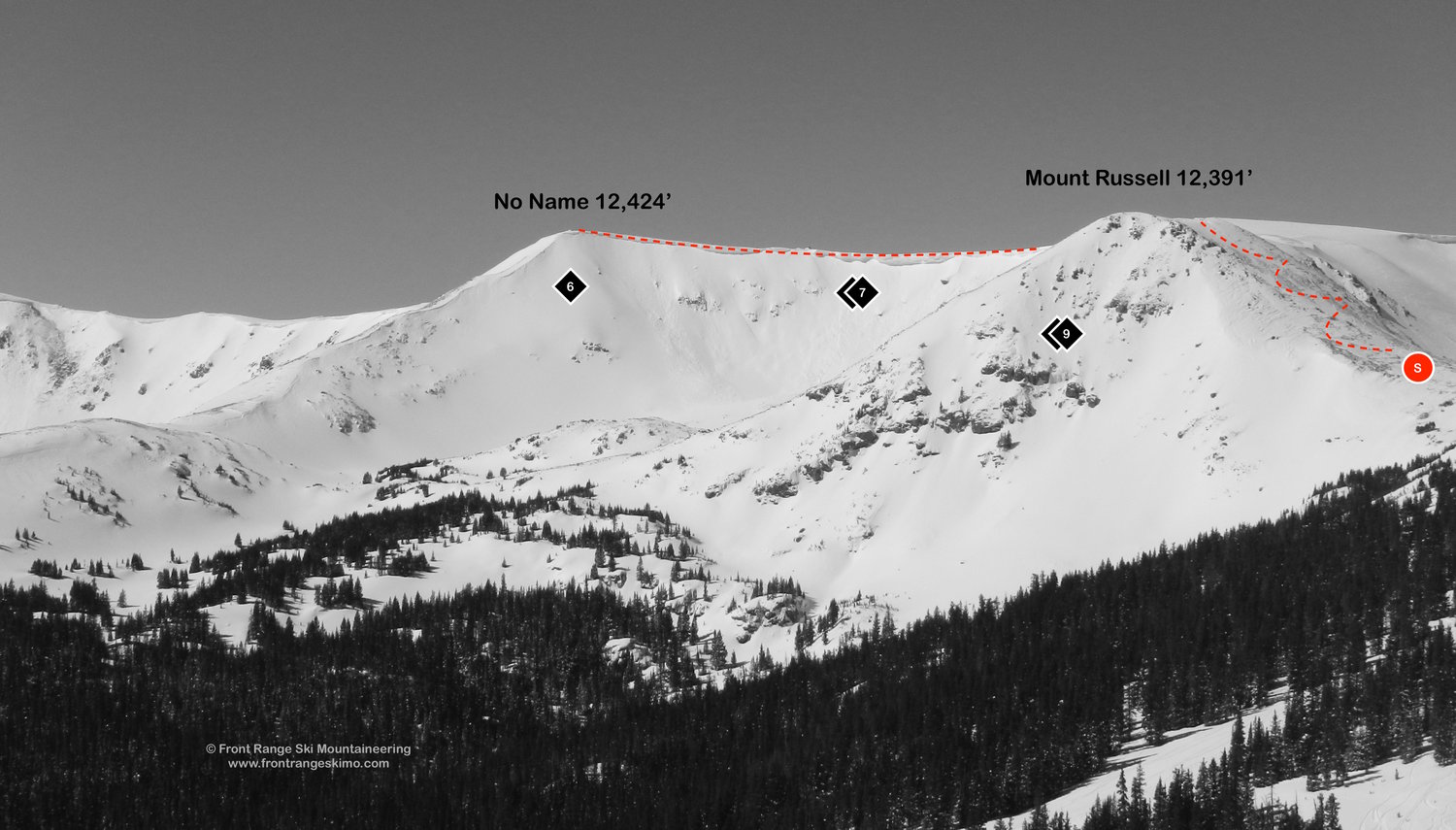
- Summit Elevation: Mount Russell (12,391’), No Name (12,424’)
- Aspect: East, Southeast, South
- Elevation Range: 11,300’ – 12,424’
- Vertical: 600’ – 1,200’
- Trailhead: Berthoud Pass Summit (11,300'), Pumphouse Basin (11,185')
- Snowmobile Access: Snowmobiles are not allowed at Berthoud Pass.
Skin Track:
There are two primary up tracks, one used to access Mount Russell and No Name, and the other for Pumphouse Basin.
Most backcountry skiers use the main skin track on the West Side to access Mount Russell and No Name. From the Berthoud Pass parking lot, cross Highway 40 to the base of Great Divide. The skin track turns southwest through the trees to CDT West and then up to the summit of the West Side at 11,945 feet. [39.8026, -105.7867]
From this high point, descend west through the krumholtz trees to the saddle at the base of Mount Russell. Climb up this slope and you are near the top of Mount Russell’s North Chutes. The summit of Mount Russell is a slightly higher rise is about a third of a mile to the west.
No Name is about two thirds of a mile west and then south from Mount Russell’s North Chutes. No Name Cirque is lined with a cornice so tread carefully here. The No Name 12,424’ point is very clear on high visibility days. [39.7993, -105.8017] If your vision is obscured by a storm or wind then it will be difficult to navigate to No Name.
The No Name Bench area is most commonly accessed via Pumphouse Basin Trailhead. Cross to the west side of Highway 40 and begin climbing west into the forest. The climb to No Name Bench is mostly a gentle rise through the forest and then up to treeline and the top at approximately 11,892’. [39.796, -105.7961]
Exit:
The Mount Russell routes exit into Current Creek. Some skiers and riders climb up to the top of Hidden Knoll after a Mount Russell descent to add more vertical. The Hidden Knoll routes and Mount Russell’s direct exit eventually bring skiers back to the Berthoud Pass Ditch. From The Ditch and exit route follows the skin track past Peter Rabbit Hut to Current Creek and then to the Current Creek trailhead.
The No Name and No Name Bench routes exit into Pumphouse Basin. The exit through Pumphouse Basin has several flat sections.
Routes:
6 – No Name – This proud route is the crown jewel of the south side of Berthoud Pass. The route dives straight down the fall line into the cirque. No Name, and every line around it, is consequential avalanche terrain.
7 - No Name Cirque – This bowl is between Mount Russell and No Name. Cornices surround the top of the cirque, and small cliffs dot parts of the face.
8 – Oatmeal Bowl – This is really the north side of No Name Cirque. Oatmeal Bowl faces south.
9 - Russell Face – This is a highly accessible zone that has proven to be of danger to backcountry skiers. There are several chutes, large cliffs, and a frozen waterfall located on Russell Face.
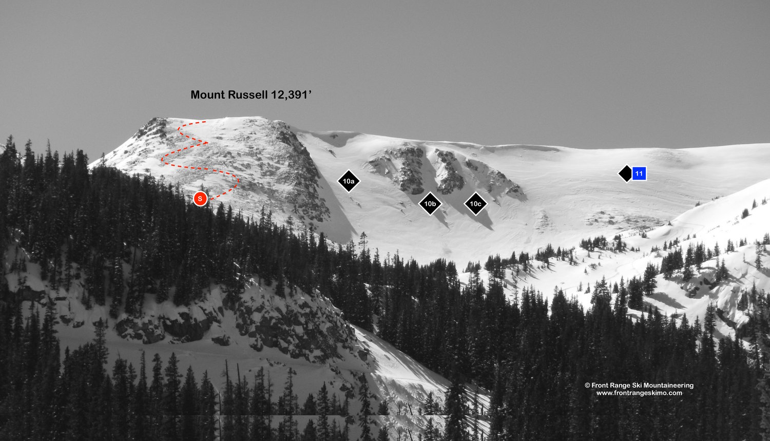
10 – North Chutes – These chutes drop northeast from the false summit of Mount Russell and into a wide-open basin. The right chute is the widest (A) with a rock wall on skier’s right, the middle chute is the most couloir-like (B), and the skier’s left chute (C) has a convex entrance.
11 – Current Creek Bench – The Bench is a large slope to the northwest of the North Chutes. A large cornice occupies the center of the top of The Bench and most riders descend to the skier’s right side of this cornice, and to the skier’s left of the North chutes.
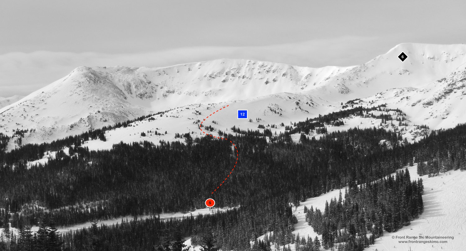
12 – No Name Bench – This broad north and northeast facing area comprises of above and below tree line terrain. There are multiple small bowls and open slopes leading into the trees, and the skier’s right side of the bench has great low angle terrain.
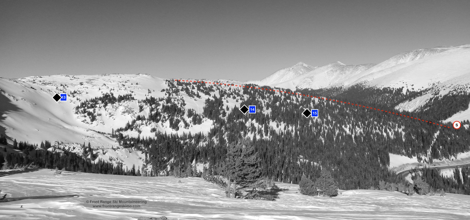
13 - Russell Basin – Russell Basin is the south-facing slope below Russell Face that descends to the flats leading into the bottom of Pumphouse Basin.
14, 15 - Pumphouse Basin – Placer Basin and Trappers Glades collectively make up “Pumphouse Basin”. Placer Basin (14) is the skier’s right side, and Trappers Glade (15) is on the skier’s left. From the top of the West Side approach you can see into the lower angle upper slopes. The middle section is steep with some small cliffs scattered throughout, and these slopes get a lot of sun.
+ WEST SIDE ROUTES
This is the West Side of the old Berthoud Pass Ski area. The lifts and lodge are gone, but it feels like the Pass sees as many skiers today as when the ski area was last open for lift service. The West Side is a popular area, and has quick access to a high point that enables you to drop into many zones including Pumphouse Basin, Current Creek, the 90s, or down the West Side and back to the Pass. Despite having a lot of skier traffic, avalanche hazard remains in this area, especially on the terrain between The Roll and The Plunge. The West Side Cliff area, which include the cliffs running from Rush Chute to Nitro Chute, was some of the terrain used in the Berthoud Pass Bad Ass competitions near the turn of the century.
- Season: Winter
- Summit Elevation: 11,945’
- Aspect: North, Northeast, East
- Elevation Range: 11,300’ – 11,945’
- Vertical: 600’
- Trailhead: Berthoud Pass (11,300')
- Snowmobile Access: Snowmobiles are not allowed at Berthoud Pass.
Skin Track:
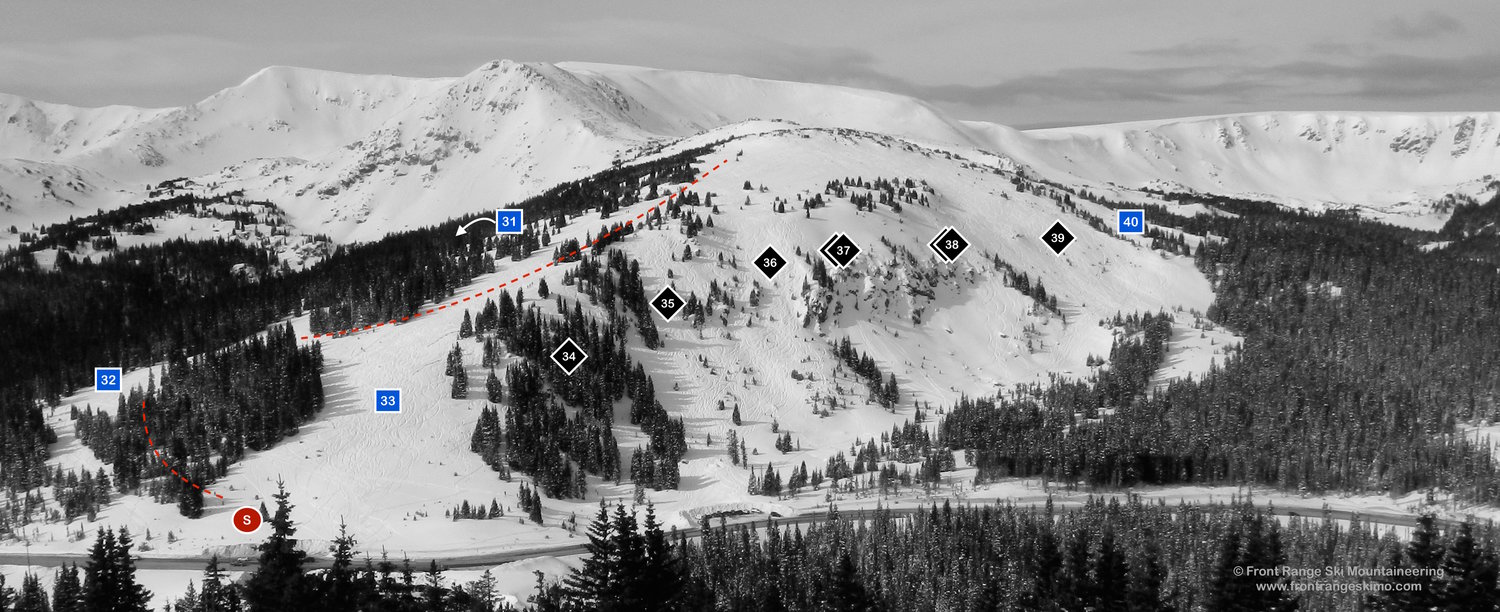
There is one primary skin track that serves all of the runs on the West Side. From the main parking lot, cross Highway 40 to the base of Great Divide. The skin track turns southwest through the trees to CDT West and then up to the weather station near the summit of the West Side. You can climb to the top and decide where to drop in from there. A boot pack line may head directly up Mainline. [39.8026, -105.7867]
Exit:
The skin track passes the top of all of the runs of the West Side. The majority of the descents exit back to the pass. There is a long traverse starting at the Meadows that leads past the West Side Cliffs and back to the Pass. Continuing down Meadows run drops you into the 90s area and Sam and Nelson’s.
Routes:
31 - Wyskis Wonder – A fun glade run. Too far skier’s right goes into Pumphouse and Highway 40; skier’s left brings you back to CDT West.
32 – CDT West – A green run at the old ski area, CDT West is mostly used for the skin track up the mountain.
33 - Mainline – Mainline descends from the summit and is used to access all of the West Side Cliff runs. It then becomes the wide run directly above the pass.
34 - Triple Rock – Triple Rock is an area of comprised of multiple chutes. Access this area from Mainline and past the Plunge.
35 - The Plunge – The skier’s right side of Lift Gully. Access the Plunge from Mainline.
36 - Lift Gully – The old ski lift line at Berthoud Pass, and host to many rock drops. Ski down Mainline to the point where the run becomes convex and take a left.
37 - Rush Chute – A series of cliffs and chutes that frequently maroon skiers who get in over their heads. The West Side Cliffs run between Rush Chute and Nitro Chute.
38 - Nitro Chute – There are several chutes on the skier’s left side of the West Side Cliffs. From the summit trend skier’s right around The Roll to the chutes and drops.
39- The Roll – The Roll and surrounding terrain are the perfect avalanche angle. From the summit ski east to where the slope disappears past a convex hump. An alternative is far skier’s left through the trees bordering The Roll, but you then need to descend “Test Slope” to the base of the Roll. Berthoud Pass ski area called it Test Slope for a reason!
40 - The Meadows – The Meadows is an area of lower angle and windswept terrain that is comprised of patches of krumholtz and clearings. It is frequently used to access the 90s area. Otherwise, break hard right to traverse to the Test Slope at the bottom of the Roll.
+ 80s AND 90s ROUTES
The 80s and 90s are some of the most popular steep skiing terrain at Berthoud Pass. This area is easily visible when driving north on Highway 40, and it is reasonable to used a car shuttle or hitchhike to access these steep routes. The Berthoud Pass Ditch cuts bisects the 80s and 90s and this allows for the easier access. The 90s and Flume are so popular that you may find moguls on the slopes! Skiers and snowboarders can also access this terrain from the top of Berthoud Pass’s West Side. The runs all end at the Current Creek Trailhead.
There are several additional hazards to be aware of in this area. The Berthoud Pass Ditch can have debris under the snow, thin coverage and rocks just below the Ditch, and large holes. Highway 40 is exposed to avalanche hazard and CDOT frequently mitigates this area sometimes leaving blast holes in the 80s.
- Season: Winter
- Summit Elevation: 11,945’ (top of West Side), 11,460’ (top of Flume), 11,290’ (Aqueduct)
- Aspect: North
- Elevation Range: 10,800’ – 11,945’
- Vertical: 500’ - 1,145’
- Snowmobile Access: Snowmobiles are not allowed at Berthoud Pass.
Skin Track:
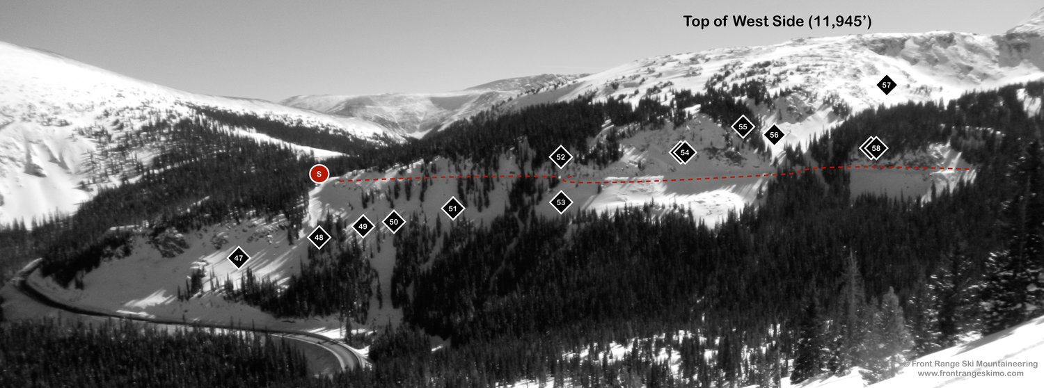
There are two common ways to enter the 80s and 90s area. Berthoud Pass Ditch bisects this area and many skiers use the Ditch access road to gain the 80s and 90s, and then hitchhike back up from the Current Creek Trailhead. The other option is to skin or climb up the West Side and enter the 90s area below The Meadows or West Side Cliffs.
See the description in the Trailhead section below on how to access the Berthoud Pass Ditch. At the Ditch entrance on Highway 40, follow the well-defined road north through the forest to the top of the Rock Garden (about 0.3 miles). Use the road to traverse to the other routes.
Another way to access the 90s area is to climb up the West Side and use The Meadows to access the Flume and 90s area. From the top of the West Side, ski down the left side of The Meadows heading directly north. At the edge of the forest there is an old wooden post. Aim for this post. After the wood post trend right and curve into Flume. To the left leads into Hourglass Cliffs. Alternatively, ski the far right side of The Meadows to the forest. Find a narrow entrance that you can follow to the top of Rock Garden.
Exit:
The 90s routes end at the old road leading to the Current Creek trailhead on Highway 40 [39.8102, -105.7785,]. The exit of the 80s more challenging to navigate and requires a hard left turn to gain the road leading to the Current Creek trailhead. Many skiers leave a shuttle at Current Creek or hitchhike back to the summit.
Routes:
47 – The 80s – Head skier’s right to the 80s when you exit the Ditch at Rock Garden. The 80s are comprised of large cliffs with limited chutes in between. At the bottom ski left to avoid Highway 40 and to get to Current Creek.
48 – Rock Garden – The Rock Garden is the first open chute you encounter on the Ditch. The first pitch is lower angle, and the second pitch is steeper and rockier.
49 - Vigilante – Vigilante is skier’s left of the trees at the start of Rock Garden, and the run trends left towards Current Creek.
50 – The 90s – Continue on the Ditch past Vigilante to a chute with the trees on skier’s left.
51 - Outlaw – Outlaw is an open face leading to an isolated chute past The 90s. The Launch Pad trees are to skier’s left.
52 - Flume – Flume is a classic Berthoud Pass Run. From the top of the West Side, in combination with The Meadows, this run can be over 1,000’ vertical. Curve right from the wooden post, and follow a gully to the Ditch and into the distinct chute below.
53 - Top Secret – When skiing Flume, Top Secret is a small stash on the left past the Ditch.
54- Hourglass Cliffs – There are numerous chutes through the Hourglass Cliffs, aka Red Dot. You can to scout this area from the Ditch.
55 - Wiebel’s Wobble – This run is the backside of Hourglass Cliffs and trends left on the edge of the trees and cliff. There is a cliff at the bottom than can be avoided, and then you exit to the Ditch. The terrain below the Ditch often holds cold powder.
56 – Nelson’s and Sam's– This be accessed from the top of the West Side. Instead of turning right to Flume, take a hard left. This leads to a creek bed that passes the Ditch and leads to the skin track from Current Creek Trailhead.
57 – Skull Bite – Skull Bite is a wind-swept zone accessed from the top of the West Side. It is not frequently skied due to being on the windward side of the mountain. The creek bed at the bottom leads to Nelson’s and Sam's.
58 – Coconut Ridge – These cliffs can be accessed from Nelson’s and Sam's or from the Ditch.
+ TRAILHEAD
Berthoud Pass Summit (11,300’)
The summit of Berthoud Pass is the epicenter of backcountry skiing on this part of the Front Range. There is a large parking lot and a small building with restrooms and a warm room that you can use to gear up on cold day. The summit is on Highway 40 and 18 miles from Empire (near exit 232 on Interstate 70) and 11.3 miles on Highway 40 from Winter Park. [39.798, -105.7771]
Pumhouse Basin (11,185')
Pumphouse Basin trailhead is the turnout off of US Highway 40 Berthoud Pass Road approximately 1/2 mile before Berthoud Pass Summit on the on the Empire. The elevation at this trailhead is approximately 11,185’. There is a pull out on the east side of the road. [39.7966, -105.7851]. This trailhead is used for mid-winter skiing on No Name Bench and Pumphouse Basin and for car shuttles for the No Name exit.
Berthoud Pass Ditch (11,245’)
The Berthoud Pass Ditch Trailhead is just north of Berthoud Pass on Highway 40. Driving north from the pass, the entrance is on the left at 0.3 miles from the top of the pass. [39.8026, -105.7772] There is a parking pull out on the right after the Ditch. After a large snow storm the pull out may not be plowed.
+ MAPS & PICTURES
Below we have included a link to a Google interactive map and a curated list of photos of the mountain.

Clicking on map above will open interactive Google map website